Which way do you ski?
Scroll your way through the story of OpenSkiStats and visualize the methods used to assess ski area orientation.
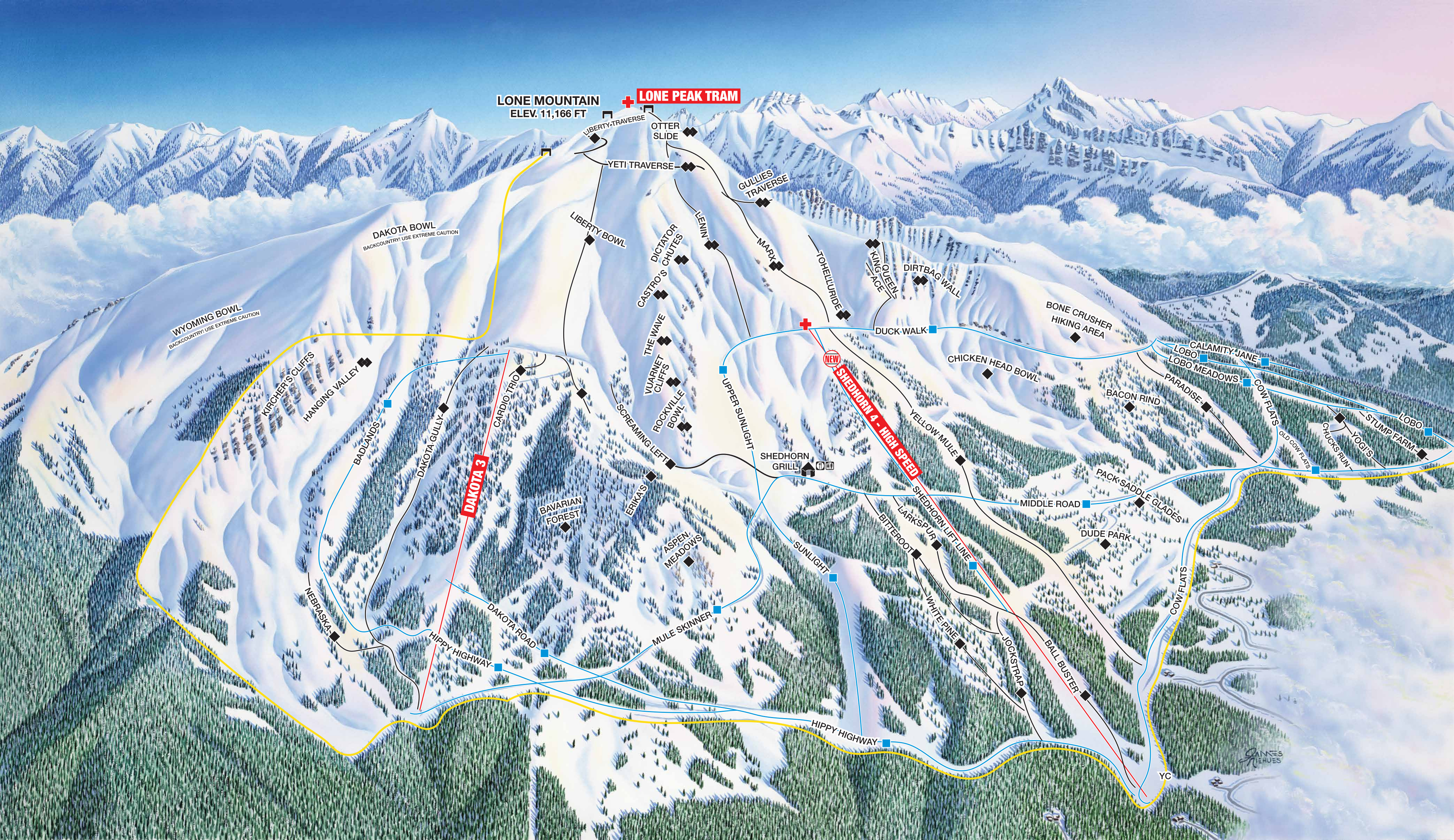
Skiers and riders, you’ve all seen these trail maps — they’re essential for navigating the mountain, finding the fastest lift, or planning your next run.
This map, painted by the legendary James Niehues, shows the South Face of Big Sky, Montana, 🇺🇸.
But have you ever wondered how common south-facing slopes are? In other words, do most ski trails in this hemisphere favor southern aspects, or are they more often found on the north side of the mountain?
We began our journey to answer this question by gathering data from OpenSkiMap, which refines OpenStreetMap to create an amazing interactive visualization of the world and all its ski trails.
For decades, thousands of OpenStreetMap contributors have worked to annotate ski areas and their trails.
In the Upper Valley region of Vermont and New Hampshire, …
… you can see the iconic Killington and its neighbor Pico.
Here is a local favorite, Whaleback Mountain.
And just north of it is Storrs Hill, where you can ski for free this season!
Analyzing this data, we can see how north-facing each ski area is by looking at its “ski rose”.
Take, for example, the Dartmouth Skiway in Lyme, NH.

These are the two signature sides of the Skiway, Holt’s Ledge and Winslow Ledge.
On powder days, you can ski from Winslow across the Grafton Turnpike and glide right to the bottom of Holt’s Ledge Double.
If we:
- gather the coordinates for all trail segments
- connect the dots
- treat each of these segments as a vector
- scale the vectors by their vertical drops
we can summarize them in a …


… ski rose!
Similar to how wind roses chart wind direction for location, ski roses characterize the directions of all trail segments at a ski area.
Each petal of the circular chart represents a compass direction, with its radius proportional to the combined vertical of trail segments in that direction.
Highlighted is the Northwest by West petal…
… to which these particular segments contribute.

And here’s the North North East petal.
While these NNE segments appear similar in horizontal distance to the NWbW segments above, their greater steepness results in greater vertical drop, and hence the largest petal of the rose.


We can do this for other ski areas too!
Here are 48 more ski roses randomly selected from the US.
Have you been to any of these? Did you remember facing north while skiing down?
And here are the ski roses for 37 US states with at least one ski area.
Do most states look north-facing to you? And, as an aside, can you tell which state has the most combined vertical?
Our analysis of the orientation of all ski areas across the globe revealed a strong poleward and moderate eastward preference.
In other words, the majority of runs in the northern hemisphere are oriented toward the north and east, while those in the southern hemisphere are oriented toward the south and east.
This trend reflects which aspects maximize snow retention by minimizing sun exposure and preferring morning sun — when temperatures are lower — to afternoon sun.


In addition to trail bearings, we have published data on other key metrics of a ski area like total vertical, number of lifts, and peak elevation for ski areas across the world.
In OpenSkiStats.org/ski-areas, you can search for your favorite ski area and explore all of its summary statistics. Whether you’re planning your next powder day or just marveling at the hidden patterns of the slopes, this may be a fresh way to see the mountains you love.
For example, below are the statistics of the five New Hampshire/Vermont mountains we saw earlier:
We hope this data inspires your winter adventures, helps you assess the climate resilience of distant ski mountains, or simply gives you a moment to pause and smell the roses.
Curious to learn more? Read our manuscript to explore the approach we took and dive deeper into our findings.